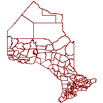
Wildlife Management UnitCoordinate system: 4269 - "NAD83" Abstract:A Wildlife Management Unit (WMU) is an administrative coverage that identifies a geographic area (i.e. numbered divisions of the Province of Ontario) which serves as a land base for wildlife research and management. These units have been developed in Ontario based on a number of factors including the environmental requirements of principal wildlife species, ecosystems, and consideration of suitability of boundaries to traditional and future users, landowners, municipalities and other jurisdictions. Boundaries are generally described by rivers, lakes, roads, and other features easily recognized on the ground. A few exceptions occur where less visible criteria (for example, township/district boundaries) have been used in the absence of suitable physical features. The Intended Use and Purpose for Collecting the Data Set or Information Holding: WMUs are used for a number of wildlife management purposes, one of which is to indicate the relevant geographic areas of Ontario where hunting open seasons and harvest quotas apply. Supplementary tables can be used and are available for download from the additional documentation section. This layer is part of what was known as the OMNR Non-Fundamental Dataset. |
Additional Documentation
-
Metadata Information
Language: eng; CANLast Update: 2013-07-12Other Maintenance Requirements:2e0ee5a9-1500-41c2-a6ce-f750c1e832beMetadata Contact:Scholars Portal, Ontario Council of University Libraries Toronto Ontario, CanadaContact Instructions:gis@scholarsportal.infoMetadata Standard:North American Profile of ISO19115:2003 - Geographic Information -
Citation Information
Ontario Ministry of Natural Resources Peterborough Ontario, CanadaThemes or Categories of the Resource: planningCadastreKeywords:ADMINISTRATION, COMPLIANCE ENFORCEMENT, WILDLIFE, SEASONS, ALLOCATION, BLACK BEAR, BOUNDARY, CARIBOU, DEER, ENFORCEMENT, REGULATIONS, SMALL GAME, UPLAND GAMEBIRDS, WATERFOWL, WILDLIFE MANAGEMENT, MOOSE, HUNTING, WILDLIFE MANAGEMENT UNIT, NON-FUNDAMENTALWILDLIFE, WILDLIFE MANAGEMENT, SEASONS, Black bear (Ursus americanus), Caribou (Rangifer tarandus), CERVIDAE, ENFORCEMENT, REGULATIONS, REGULATION, WATERFOWL, HUNTING, ALCESManagement, Gestion, Compliance, Conformité, Wildlife, Faune, Wildlife management, Gestion de la faune, Boundaries, Frontière, Enforcement, Contrôle d'application, Regulations, Règlements, Regulation, Réglementation, Game (Wildlife), GibierPlace Keywords:Continent > North America > Canada > OntarioPurpose:WMU are used for a number of wildlife management purposes, one of which is to indicate the relevant geographic areas of Ontario where hunting open seasons and harvest quotas apply.Dataset Language:Status: onGoingUpdate Frequency: asNeededSpatial Representation Type: vectorExtentWest Longitude: -95.153667East Longitude: -74.320109North Latitude: 56.859365South Latitude: 41.676556
Supplemental Information: -
Spatial Representation - Vector
Geometric Objects:Object Type: compositeObject Count: 151 -
Reference System Information
-
Data Quality Information
Scope Level: dataset -
Distribution Information
Distributor:Ontario Geospatial Data Exchange, Ministry of Natural Resources (OMNR) Peterborough Ontario, Canada