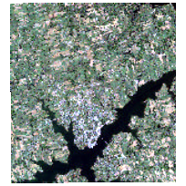
DMTI Satellite StreetView (SSV) - Charlottetown, Prince Edward IslandCoordinate system: 32620 Abstract:DMTI Satellite Streetview is an integrated product containing orthorectified and pansharperned QuickBird Satellite imagery data combined with CanMap streets data. It provides satellite imagery at 60cm along with boundary and point data. This dataset contains satellite images taken in 2009 using natural colour composite bands, covering Charlottetown, PEI. Supplementary data files and documentation are available for download from the 'Additional Documentation' section. |
Additional Documentation
-
Metadata Information
Language: eng; CANLast Update: 2015-09-01Metadata Contact:Scholars Portal, Ontario Council of University Libraries Toronto Ontario, CanadaContact Instructions:gis@scholarsportal.infoMetadata Standard:North American Profile of ISO19115:2003 - Geographic Information -
Citation Information
SeriesName: DMTI Satellite StreetView
DMTI Spatial Inc. Markham Ontario, CanadaThemes or Categories of the Resource: imageryBaseMapsEarthCoverKeywords:SSV, Charlottetown, PEI, Prince Edward Island, Queens County, P.E.I.SATELLITE SURVEYS, REMOTE SENSINGSatellites, Remote sensing, Télédétection, PhotographsPlace Keywords:Continent > North America > Canada > AlbertaDataset Language:Status: completedUpdate Frequency: unknownSpatial Representation Type: gridProcessing Environment:Microsoft Windows XP Version 5.1 (Build 2600) Service Pack 3; ESRI ArcGIS 10.0.2.3200ExtentWest Longitude: -63.247851East Longitude: -62.997358North Latitude: 46.380382South Latitude: 46.192165
Supplemental Information: -
Spatial Representation - Grid:
Number of dimensions: 2Axis dimensions properties: -
Reference System Information
-
Data Quality Information
Scope Level: datasetPansharpened images taken by the Quickbird Satellite are mosaicked and orthorectified to account for differences in elevation and terrain. The Quickbird Satellite provides images in five bands, one panchromatic and four multispectral. Images are radiometrically corrected, sensor corrected and geometrically corrected with spatial mosaicking and colour balance applied.
-
Distribution Information
Distributor: